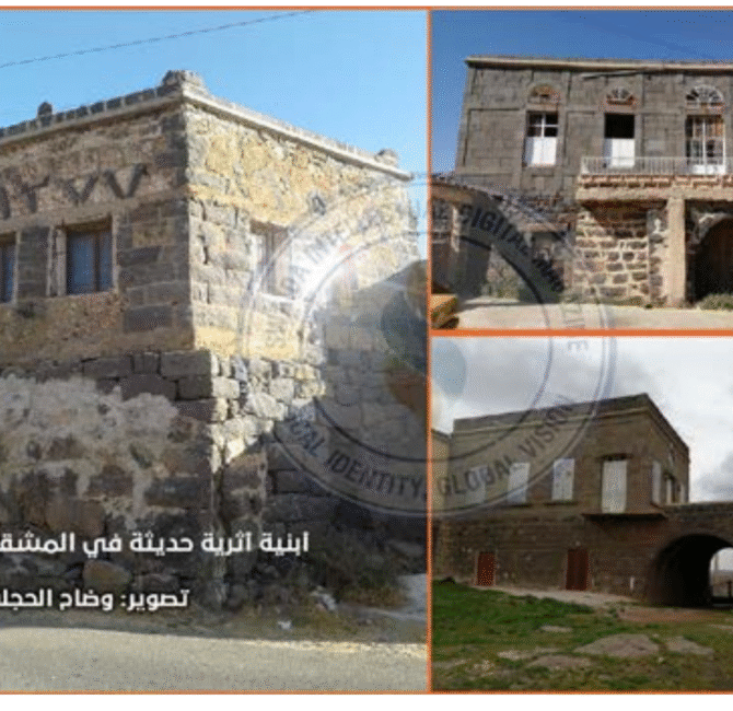


Al-Hajali, Waddah. Field documentation, 2026
1. Introduction
The southern region of Swaida is particularly rich in basaltic architecture, whose use dates back to the Roman and Byzantine periods. The endurance of these structures through the centuries stands as a testament to the strength and durability of their stone. Within this landscape, Khazma emerges as a site worthy of study—not as an urban center, but as a model of multi-phase rural settlement.
This study examines the site of Khazma, located at the far southeastern edge of Swaida, situating it within the basaltic zone of southern Bilād al-Shām (Greater Syria). The goal is to describe the village and its architectural character. Preliminary results from the Princeton University mission indicate that Khazma represents a typical basaltic rural settlement, notable for its reuse of earlier architectural elements.
2. Geographical and Historical Context
Khazma lies along the banks of a seasonal wadi—a natural corridor dividing the southern basaltic uplands from the eastern plains. This strategic setting connects it to a network of major archaeological sites, emphasizing its role as a link between them.
To its north, about 5 km away, lies the village of Malah (also known as Malah al-Sarar), an important historical settlement that once served as an administrative center whose surrounding countryside contains scattered ruins. Nabataean inscriptions have been found in Malah—one carved into a lintel and another on a statue—while Ghassanid crosses and symbols appear on doorframes. The village also features a notable tower and ancient water reservoirs. Remnants of Roman-Byzantine architecture in Malah resemble those in Khazma, including modest churches and similar stone pavements.
To the southwest, 7 km away, lies Amtan, a Nabataean-Roman-Byzantine site with comparable inscriptions and a grid-planned street layout. To the east stretches the steppe (al-Badiya), which borders Khazma directly, positioning the village as a strategic link between the mountain and the grazing plains.
Archaeological evidence from Khazma reflects several distinct historical phases:
- Classical Period (2nd–4th centuries CE): A Roman-era settlement with a grid-planned street system, monumental gates, and broad houses likely used for gatherings or commercial activities.
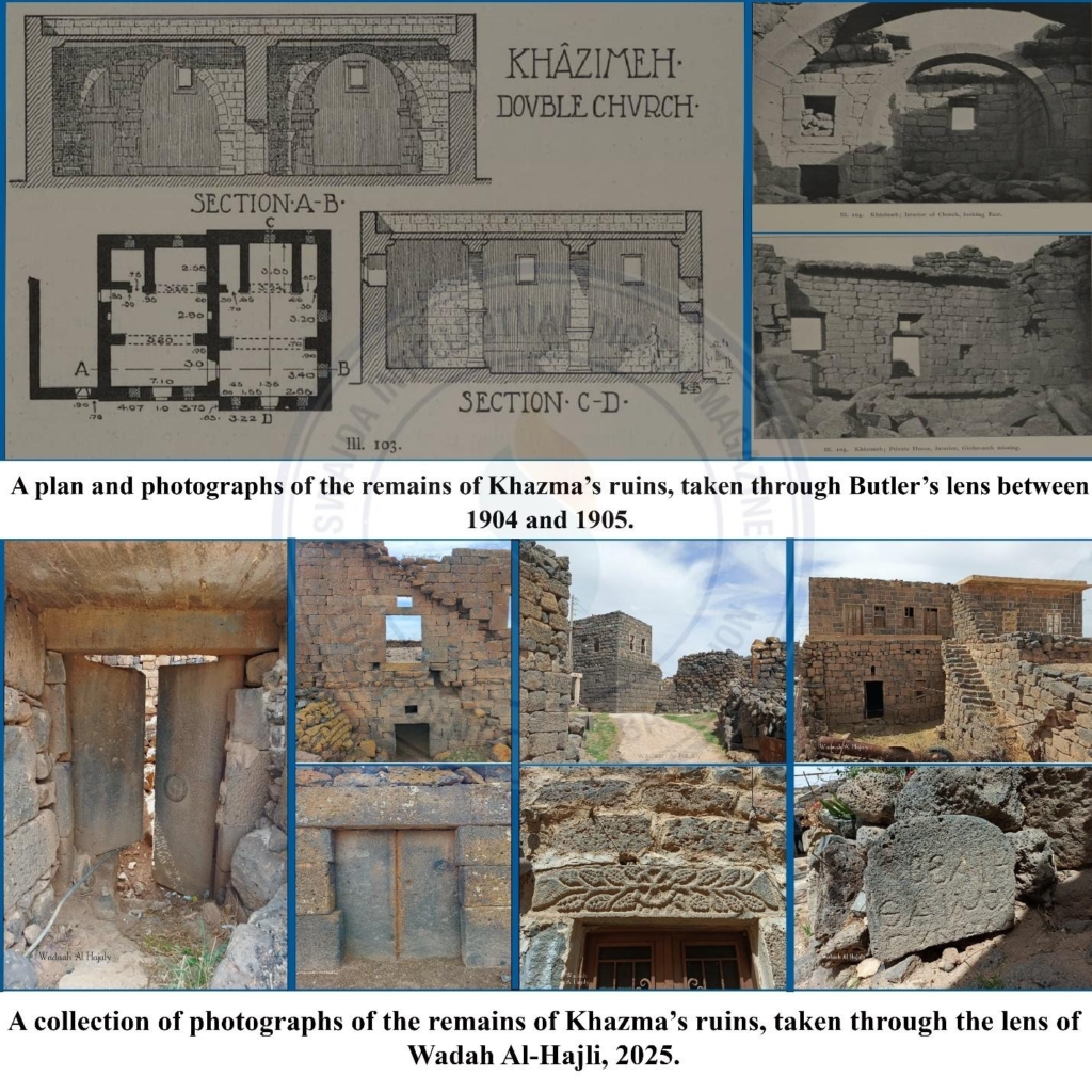
- Byzantine Period (5th–7th centuries CE): Represented by the remains of a double church and internal arches.
- Early Islamic Period (7th–13th centuries CE): Reuse of Roman gates for defensive purposes after the Islamic expansion, fitted with heavy door leaves.
- Modern Heritage Phase (20th century): Local reconstruction using stones reused from Roman and Byzantine ruins.
3. Architectural Description
Residential Architecture
Khazma appears to have been a prosperous rural settlement, as suggested by the size and sophistication of its houses. Its streets are well-defined, relatively straight, and lined with raised stone pavements. Many homes consist of a single vaulted story or two reinforced levels, whereas some larger houses include two vaulted floors and up to three or four upper stories—similar to buildings in the village of Majdal.
One surviving structure shows a three-story house with a large window and an upper-floor entrance in its front wall. The doorway bears a small carved niche above the lintel, a characteristic decorative feature. The lower level is filled with debris from collapsed stone floors and ceilings. Many doorways feature carved lintels above courtyard-facing entrances, sometimes adorned with column capitals beneath inner arches—a motif also seen in basaltic cities such as Bosra and Shahba.
Among the most striking features of Khazma are its large basalt doors—seventeen massive doorways distributed throughout the residential fabric. These well-crafted stone doors, typically double-leaved (2.5–3 m tall and weighing up to 1–2 tons), sealed alleyways and street entrances. Their imposing design raises interpretive questions: might they have evolved from an urban Roman function to a defensive role resembling those of Umayyad desert fortresses?
Religious Architecture
At the village center stands a double church, built in a simple basilical plan (20 m long, with plastered basalt walls). The southern church, symmetrical and modest in design, is built of square-cut, porous brown basalt. Except for the roofing slabs, it remains largely intact. Its nave is nearly square with a single transverse arch; the sanctuary is rectangular, flanked by two narrow, two-story side chambers.
The adjoining church, which is almost completely preserved but darkened due to blocked windows, has a smaller square nave topped by a single arch. Its sanctuary is offset to one side and accompanied by only one side chamber—the northern one, much wider than its counterpart in the southern church. The two buildings are connected by an interior doorway. Windows are small and placed high in the walls. Both structures have extremely simple interiors, but traces of plaster suggest that the rough walls were once coated.
Streets and Courtyards
Khazma preserves a relatively straight street grid (3–4 m wide) with elevated stone pavements and about 28 large houses averaging 150–250 m² each.
Door lintels display Roman classical vegetal cornices—projecting stone moldings carved with deeply detailed acanthus leaves (5–10 cm deep), a decorative style identical to those seen in Bosra.
Courtyards exhibit Byzantine atrium-style layouts: open central spaces aligned with the main entrance and surrounded by rounded interior arches supporting the upper rooms. These structural arrangements enhanced light and ventilation—an architectural adaptation to the region’s hot, arid climate.
4. Conclusion and Discussion
In comparison with Malah, the stone pavements appear similar in design, yet Khazma displays a far greater sense of continuity. The pavements in Malah are raised basalt slabs about one meter wide, but in Khazma they form an unbroken connection with the existing alleyways rather than appearing in separate, discontinuous segments as in Malah.
Both settlements feature simple, single-nave churches coated with yellowish plaster. However, Khazma stands out for its double Byzantine church. Butler’s archival reports describe this structure as unusually configured, its walls covered with red and yellow plaster—suggestive of advanced Byzantine mural decoration comparable to that of northern Jerash, though executed on a smaller, rural scale (approximately 300–400 m²). This feature distinguishes Khazma from Malah, whose individual churches measure only around 15 meters in length.
In Khazma–as-Safia, the basaltic ḥalas (“urban gate”) design is comparable in shape and size. The buildings there rely on basalt stone masonry and include fortified entrances, indicating continuous occupation since antiquity—even though some settlements diminished in later periods.
At Imtan, Nabataean influence is evident in the flowing vegetal cornices and decorative motifs, whereas Khazma integrates Roman arches, combining several styles into a multi-phase basaltic village that made extensive use of reused architectural elements.
At Bosra, the large stone ḥalas gates represent the direct Roman prototype from which Khazma’s massive versions evolved. In the eastern steppe, these gates were reinforced with heavy stone leaves (1–2 tons each), adapted for tribal defense against raids.
Thus, Khazma stands out in southern Bilād al-Shām as a vivid example of the interaction between Roman (grid-planned streets and civic gates), Byzantine (double church and internal arches), and Early Islamic (defensive reuse) architectural traditions—all integrated within a resilient basaltic fabric designed to withstand earthquakes.
Khazma therefore represents an important case study of rural architecture in Swaida: it reflects adaptation to a basaltic environment, creative architectural reuse across historical eras, and a long continuity of habitation—occasionally interrupted by drought or warfare.
This study recommends conducting a comprehensive archaeological field survey, including systematic excavation, stratigraphic analysis, and detailed architectural documentation, to preserve the unique testimony this site provides about rural civilization and settlement continuity in the southern Levant.
Sources
- Butler, Howard Crosby. Publications of the Princeton University Archaeological Expeditions to Syria in 1904–1905 and 1909, Division II: Architecture and Itinerary, Section A: Southern Syria (Part 2). Leyden: Brill, 1914.
- Ambraseys, Nicholas. Earthquakes in the Eastern Mediterranean and the Middle East: A Multidisciplinary Study of 2000 Years of Seismicity. Cambridge University Press, 2009.
- Al-Tabari, Muhammad ibn Jarir. Tarikh al-Rusul wa al-Muluk (The Great History), vol. 9. Edited by Muhammad Abu al-Fadl Ibrahim. Cairo: Dar al-Ma‘arif, 1879.
- Al-Biladhari, Ahmad ibn Yahya. Futuh al-Buldan (Conquest of the Countries). Edited by Salah al-Din al-Munajjid. Beirut: Dar al-Kutub al-‘Ilmiyya, 1866.
- Peeters, Paul. Bibliotheca Hagiographica Orientalis. Brussels: Société des Bollandistes, 1930.
- Al-Hajli, Wadah. Field Documentation Report, Khazma Village, 2026.
P.S: The original text, submitted by the author in Arabic, has been translated into French and/or English using artificial intelligence tools, with subsequent human revision to ensure accuracy. The original Arabic version remains the definitive reference for the author’s ideas, arguments, and scientific content, and is consulted in case of any discrepancies or interpretive issues between language versions
Citation
Al-Hajali, W. (2026). Khazma: A Rural Basaltic Site Revealing the Architecture and History of Southeastern Swaida. Swaida Intellectual Digital Magazine, 1(4). https://doi.org/10.5281/zenodo.19422816